Spatial Positioning
3D Geoinformation for Defence and Intelligence
Challenge
To procure, visualize, and disseminate high-quality and up-to-date 3D geoinformation about urban areas and critical infrastructure worldwide.
Solutions Created By Us
We provide worldwide 3D geoinformation as well as high-performance 3D GIS software based on its expert knowledge of the requirements of governmental and military customers:
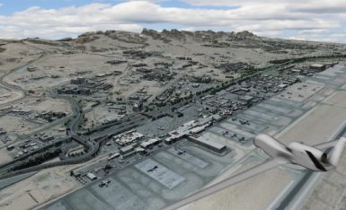
– GAF Elevation Suite: GAF produces very high and high-resolution imagery, digital elevation models, and other 3D derivatives such as building (block) models with spatial resolutions of between 0.3 m and 10 m-based on a multitude of current Earth Observation (EO) satellite systems, using archive or recent satellite data.
– GAFmap: GAF’s Desktop GIS software supports realistic (multi-user) 3D and VR visualization – including for large data quantities and offline scenarios. With the Pack&Go and GAFmap Express extension, simulations can easily be shared with team members and partners.
Customer Benefits
– Skilled provider of comprehensive satellite data services and products. The company’s independence allows it to have a neutral approach to selecting the best data and products for customer requirements.
– Rapid provision of elevation products on request or from stock is possible for areas all over the world.
– Optimized data availability through the use of different satellite systems.
– Best possible spatial resolution, horizontal and vertical accuracy as well as object representation for satellite-based elevation products and 3D geoinformation.
– Reliable, reproducible, high-quality 3D information especially suited for sophisticated object and spatial analysis, including change detection.
– Customization of standard products and post-processing.
– Additional data delivery formats and GIS software optimized for 3D and VR visualization.